Incarna Gaming Network
Choose your world… and bring your characters to life!
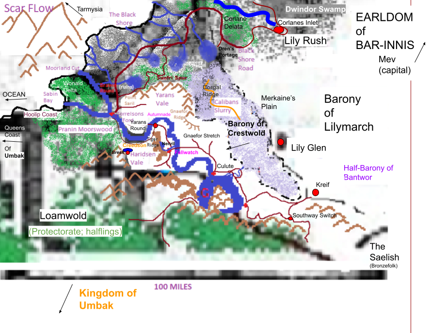
Crestwold Barony of Dunstrand

The Barony of Crestwold is located in the Earldom of Bar-Innis, within the Grand Duchy of Dunstrand. It is also called “Crestwold’s Shore”.
Ruler: Baron of House Cerstwhile.
The Cerstwhile family can trace its origins back 1000 years in the region – though not always as the Baron, as they have been for 700 years. They began as a cavalier branch of a Riverdan family through marriage to one of the daughters of Sira Derrick Hogon. The Hogons came from Bar-Innis, in the northern reaches somewhere. The lineage is sure to go back further in the region, but it was only at the point where they gained notoriety and some land that it becomes concrete. The area was originally named the Hogon Landstead.
It is a quiet place in the SW corner of the earldom of Bar-Innis where nothing ever happens and there are no real opportunities. It has good roads (though few), and is mostly self sufficient and little exports outside of its own lands. It does have one of the only passenger ports out of Dunstrand outside of Bar-Innis and the baronies of Tarmysia – the the port is mostly a trade port and small. There is a minor military presence, but the buildings are old and little expense is made to keep them staffed.
Notable Events and Happenings
Adventures Referenced: Ashfall Uncovered, Transformation of Crestwold (Campaign Arc) pt. 1
After Harvest Faire of Ezrilus
The Red Reed Feast – Each year, towards the end of the year in the fall, there is a large gathering on the Red Reed Plane about 5 miles from the Broken Switch Inn – its a flat raised large field and nothing grows nearby but scrub and [red] reeds (in the fall – they are normal by winter). Its up against the hills at the end of Lake Greflan, and there is a strange natural amphitheater. Its the largest of the fall festivals in southern Bar-Innis. Acting troupes, entertainers, bards, and common folk gather from all around. The Baron of Crestwold pays for a great deal of the food and mead. Its four days of celebration and feasting. The highlight is the pugilist tournament – it runs all four days, with those who wish to participate coming 1-2 days early to qualify. From 4-5 baronies, the pugilist experts come to win – the prize is always a horse and 5 gold coins, plus whatever winnings can be made from gambling.
Places and Items of Interest
- History of Crestwold (in Dunstrand)
- Places of Crestwold
- Point Saril
Features
Sabin Bay
The bay off the coast of the Pranin Moorswood is full of sharp rocks and treacherous sand bars and tides. No ship lands in Sabin Bay, few even anchor there – especially if the wind is blowing.
The Black Shore
The slurry injects a nasty black brackwater along the shore, causing a line of black in the sand. It is a marshy, salty place where tide flows and fresh water meet and mix.
Black Shore Road: The road is used only in the summer when things are very dry. Several attempts have been made to put a caravan way station along here and none have succeeded. The road is an old trade route, and there are several ruins of settlements off its path. The road is under water in several spots most of the year.
- Sunfri Spur: This is the old road, long fallen into disrepair. It is overgrown and covered in standing water in parts. Travelers are warned to stay away because of the Moor Cats and bandits that are said to make their home here.
- Road Post of Brawin Round: This is along abandoned road post for guards from Torrelsons Ford. It was meant as a stable and forward warning post in times of war but it fell into disrepair and now its collapsing. It consists of a main building, an a stone long hall meant to have an additional 10′ tower on it. It has a massive stone fire pit as a warning beacon, cracked and filled with water now.
Steadings: A few places have consistent dry land. Enterprising families have created a few steadings over the last several hundred years. Each one consists of a extended family of 20-40, about every 5-7 miles.
The Crest
The Wainstone Hills
The Wainstones separate Loamwold from Crestwold, and feed into Greflar fens and Lake Greflar.
Lake Greflar and the Greflar Fens
The lake is surrounded by a ton of fends, collecting much of the nearby run off. When the wet seasons come, the lake rises – it is very shallow. The dry bed that connects Calibans Slurry miles away is filled and travelers are forced to use the bridge at Autumnade.
Tiger Ridge
Mud slides (over a thousand years) have caused stripes of different color to appear facing southwest. Used to be called Nenrils Ridge. The broken Nerril Tower ruins sits atop it to the north, slowly being pulled down the ridge by mud slides. High on the crags above Postdam Falls is the old Red Bone Monastery at the south end of the ridge. The territories of Krellian comprise most of this area.
Yarans Vale
At one time, Umbak had a foothold in the barony, and the capital was Yarans Vale. There was a large clash of armies, and the Umbakains were driven out, and eventually driven out of all their steadings – including those in Loamwald territory. It is a lonely feeling place, where the wind blows over the ruins of Umbakian villages and the town of Helmandal – once the seat of Umbakian power. It is said that the soil of the vale is blood soaked and cursed – the soldiers of Umbak and Dunstrand Vale forever locked in mortal combat. Strange lights are seen in the vale – folks whisper that these are the souls of the soldiers.
Point Saril: Point Saril was once a town and way station for merchants when the area was under Umbakian rule. A lighthouse was even put in, to help those lost in the moors of the Black Shore find their way. Almost all sits abandoned and avoided now. Moor Cats are known to prowl nearby.
Gnaefor Ridge: A ridge line that was a natural break, dividing the area of the barony in half. At the top of it once stood Helmandi Keep – the source of power for Umbak in the regions. It now lies in ruins. Part of the ridge line collapsed hundreds of years ago, taking down part of the wall. It is avoided, though sometimes adventurers seek it out. Few return and those that do speak of treacherous cliffs, falling apart walls, wailing spirits and a lack of treasure.
Calibans Slurry
A massive stretch (30 miles by 20 miles) of soupy, nasty back water liquid. Over a thousand years ago, Sir Caliban tried for a dozen years to build a holdfast in it, but they inevitably sank.
Broken Switch Inn
The “southern gateway to Crestwold”; Caravan services, wagon wright, mules and some horses. Halfling rum and pipe weed is also sold here from Loamwold. Each year, the After Harvest Faire of Ezrilus is held nearby – on the trade road to The Saelish.
Ruler: Family owned for 200 years; “Minister of Southway Switch” – has power to execute legal matters in the area.
Pop: 195 (“Southway Switch” has 130 and the hamlet of Galloway Switch has the rest about a quarter mile away near a ridge with orchards)
– During the Ezrilus Red Reed Feast fall festival the population adds another 50-75 who prefer to stay in town instead of at the festival grounds.
- Fife’s Road: Leads NE out of the crossroads the Inn sits on… goes past the edge of the slurry with trade into Lilymarch and interior of Bar-Innis. The Margoye Switch is used in Jan-March during the wettest and runoff season – the road is flooded in parts and the switch is dry, but adds a few hours to the journey.
- Old Saelish Road: Leads east from the crossroads, into The Saelish
- River Road: Leads west into Crestwold
Torrelson’s Ford
Located at the fork of the Murchart River, its mostly self sustaining and exports rice and fish. Donk’s Travels = large Inn.
Ruler: (Capital of Barony); city proper operations by mayor.
Pop: 5,100
Hamlets: Willtheson (190; yes, its “will the son” who founded it – 3rd son of the original Baron Crestwold), Svell (180), Moorwatch (400), Caravel East (135), Caravel South (215), Blackroad Bell (380)
Yarans Round: A half moon of fertile land between Yarans Vale and Torrelsons Ford – Hamlets of Frenan (90), Norover (75), and Makitmo (240); Town of Torvinnan (500); farm steadings of Balewater, Mareshead, Goldwind and Somerlams.
Brawin Round: This is a loop road that leads between Brawin Road Post and Brawin River Post (on the shores of the north fork of the Murchart River) in the Black Shore. Its completely fallen into disrepair and crumbling apart. Both places were equipped to have a contingent of horses, and a fortified hall with tower and low wall around a position. Both had a stone pit for a large warning fire if need be. It used by bandits, homeless, travelers and they are generally avoided except in numbers that will dissuade Moor Cats.
Red Grass
Located on the edges of Lake Greflan (called Rumbarrel lake – halflings once a year tradition float barrels of rum for humans to find); Is mostly self sustaining and exports rice and barley.
Ruler: High Mayor (surrounding territories administered by “Sheriff of Red Grass”)
Pop: 1,600
Hamlets: Hotherwale (150), Crenmoth (170), Morgans Bend (430), Autumnade (85; expands when seasonal flood force travelers to use the bridge)
Routes: River Road > Leads west into Crestwold from Southway Switch to Torrelsons Ford
Krellian
Divided by the Postdam Falls and the Orgrimson River (river is very muddy here – feeds into Murchart), it consists of North Krellian and South Krellian.
Ruler: High Mayor Sir Jeffrey Mecrem – Vassal and ancient land holder; although not hereditary, Sheriff title for surrounding lands always passed to family member usually) – located in South Krellian. Two other ancient landed families (Offhouse and Mikkels) have lands and operations around Krellian; All of the 3 Knights of Krellian are Baronial Bannermen.
Pop: 960 (North) + 780 (south)
Hamlets: Gilenmored (60), Kestleway (450), Fallwatch (650; Sir Benjamin Amalor is the Mayor here), Everly (210), Gleasport (190), Rakefield (220; at the old Strayol Crossroads to the east – has a full sized inn: Good Candle Inn), the Red Bone Monastery (150+?) above Postdam Falls on Tiger Ridge. The monastery orchards and lands are farmed by Gleasport inhabitants while the monastery itself is a place of hospice, though it was once a place of service and training to the Green Church)
Strayol Crossroads: The Strayol family steading stands deserted and crumbling on the south side of the road – though its church is used by the wyld faith now. The village of Rakefield sites entirely on the north side of the road. The area is ancient, settled long ago when Umbak held this part of Dunstrand Vale. The church of Balthazaar built right at the crossroads has been dedicated to that god, Aerna, and Gaia over the ages. Its stone foundations have held against several sieges as a refuge for commoners in times of trouble. The graveyard of the Umbakians is still sometimes visited by pilgrims and the mausoleum of the Strayol family has been converted to a shrine to Aerna.
Haridsen Vale: Although this is technically considered part of the fief of Krellian, it is inhabited almost entirely by halflings. They are the primary trading partners with Krellian. Tiger Ridge separates this area from the human occupied areas of Krellian.
History of Crestwold
- CY 7951 – The Moorswood Blight